Showing posts with label caspian sea. Show all posts

Saturday, October 29, 2011

The water of old volcano based Crater Lakes may evaporate and the Lava may appear to signal activation of old volcano.

Well, it seems the 23/10/2011 Van Erthquake, as early as one month ago, had given many signals to warn that it is likely. But, for such an area people it is not easy to evacuate entire city because of such very small volcanic Lava, not even covering 500 meters width soil. This Lava even burned the feet of one villager living in this Ercis area, one month earlier the earthquake.
The Location of the old volcanic Lava is in ERCIS of Van,
Whereas, the Earthquake epicenter is in TABANLI of Van as seen in  map below (Figure 1.).
In general the eruptions not appear from the middle of crater but only one side of the crater.
Topographically, there is not really a high rised appearence volcano here, but it is very possible that Lake Van itself is a crater Lake and underneath is a very very old flat, not high rised volcano part.


Figure 1.

Figure 2. Lava soil in Ercis/Van.
Compared to big Lavas of very active volcanos, the Lava seen in ERCIS of Van is not really much. (The Lava appears as red at above photo taken on October 2011.). The exact formula of the gas has not been investigated in detail, however it very possible that it is relatively non toxic flammable gas, such as C4H10 . A jeochemist-Volcanologist should investigate the deep soil composition if needed.
A jeochemist-Volcanologist will find out what possible element will produce gases, for example Uranium under certain conditions gives radon gas etc. (Radon is not flammable).


Video 1. Lava gas burning.
Above video shows the volcanic Lava in detail. The villagers of ERCIS describes the Lava as 'The soil is burning itself, some gas is coming out from soil and burning spontaneously.
The district responsible people was just about to investigate issue by taking gas samples or asking for volcanologist, whether some people is burning it illegally; or, it is the nature itself, the Lava coming from old volcano. It is also possible that the gas itself is not that much flaming underneath the soil, but some air-present factors causes gas flaming*.
After 23/10/2011 Van earthquake, Experts agreed that it is indeed Lava coming from the soil.
Lava contains burnable gases leaking from the soil, thus even heavy rain or water can not stop from burning as shown in figure 2.

Undersea volcanos also leaks gases, but since they are in deep water no burning appears, or hardly brief flames occur, their ashes dirties the water; or, if strong, gives ashes towards sky.


Figure 3.
After the 23-10-2011 7.2 mAGNİTUDE Van Earthquake, small earthquakes more than thousands continued at Van. Some them were only aftershocks of the same epicenter(Tabanlı), however, though smaller than 6 magnitude, new epicenter (Bitlis) originated Earthquakes caused some landslides under already wery weak, already very damaged big heavy buildings. Such a weakened building lost its base support and fall over the street, fall over its door to level on street. The photo on the left in Figure 3. is the photo of the heavy building prior to big, 7.2 magnitude Earthquake.
The videos below shows both the undamaged building and how the damaged building leveled. Not all the buildings on the same street damaged, however, this building was about 40 years old, older than the other building. Was its engineering different, (too long over few supports?), was it too old with Chloride rich wetness? soil liquefaction? we do not know. We know that this building endured to the big 7.2 magnitude Earthquake very well as compared to many badly engineered buildings.
But, I myself would not stay in such an already damaged building if thousands of aftershocks with new earthquake epicenters going around over such a soil.


It is also possible that some Earthquakes which are described as 'subduction zones' behave differently to cause more after Earthquake events, such as Landslides if at mountain area.
Some weak, slow developing subduction zone problems show themselves only as floods on Continents.
Subduction zone earthquake triggering chemical events occur at enormously greater depths than elsewhere on Earth, but seismicity measured damages/shakes is limited to the outermost 20 km of the solid Earth.

File:ConMarRJS.jpg
Figure 4. Some already established coordinates on Earth at where rather subduction one type Earthquakes are likely. Whether subduction zone Earthquakes correlates with relatively dropping-towards-to-low-temperature requires further investigation by myself.

Iran 2003, Indonesia 2004, Kamchatka 2006, Sichuan 2008, L'Aquila 2009, Haiti 2010, New Zealand 2011, Tohoku 2011, Van 23/10/2011 are all subduction zone earthquakes.
Earthquake size is proportional to the subduction zone length. such subduction zone earthquakes may occur every 100 to 200 years; the longer Earthquake interval may indicate unusually large stress buildup and subsequent unusually large earthquake slip. tHE WORD 'mountain stress' is used to describe many chemical reactions towards new chemical products which occur in mountain eventually leading an earthquake, landslides or mountain liquefaction.
If the mountains around subduction zone area are very strong because of enormous mass/weight against chemical change stress, they resist to possible shakes many hundred years.
However, Van subduction zone is short and total very close mountain mass around Van  is not very big, there is a Lake pit, thus though not too big, frequent earthquakes occur in Van. 


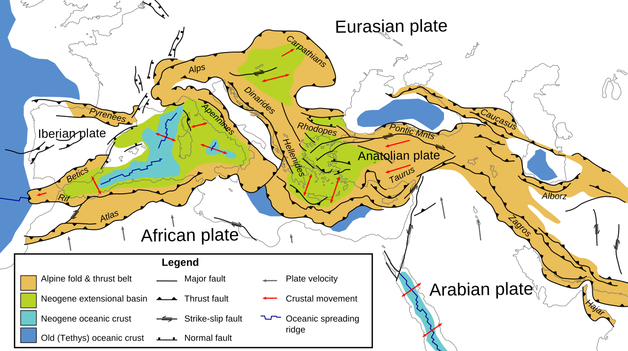
Figure 5. BITLIS-ZAGROS subduction zone fold(shown as blue barbed line under Van Lake ). Established Earthquake related fault lines around Van Lake at which 23/10/2011 7.2 magnitude Earthquake occurred.

File:Tectonic map Mediterranean EN.svg

Figure 6. Subduction zone is showed as barbed lines on brown colored areas.
Mountain chemistry representing areas are colored brown. In this map it has not been shown whether Lake Van is, recent section of the geological time scale (Neogene Oceanic Crust).

World Map Of Volcanoes
Print this MapPrintBuy This MapBuyEmail this pageEmail This LinkSave this MapSave

Figure 7. World major volcanoes
Not all volcanoes are similar. Some volcanoes are rich in for example Magnesium, thus they are more flammable from others. Ararat mountain is not known for its prominent burning Lavas, maybe there are Chloride chemical reactions around to decrease flammability of Magnesium. Any old volcanoes are rich in dry ice (The well known gas CO2 becomes dry-ice under high pressure, dry-ice looks similar but is not regular ice form of liquid water ).When the pressure lessens, the ice CO2 form turns into gas form and at first swells the mountain land, then at a point, CO2 escapes from mountain, causing gas-free cavities in mountain; eventually, collapse of cavities around/under mountain followed by Earthquakes. That the Earthquake is smaller than 8.0 magnitude means that the gas-escape-resulted-cavities in mountain were not big. The change from liquid/ice to gas occur when different-wavelenght-sunlight absorbed by mountain. (Sometimes just the opposite occur, rather than the gas, the liquid/ice form of CO2 increases, may displace  another liquid/water over lands; how this chemistry correlates with legendary unusual flood story/Naoh Arc of Ararat...).
In other planets such as Mars, magnesium-like flammable chemicals are absent, thus no burning Lava forms, in Earth there are more chemicals to create Lava all around the earth.
Such Earthquake events might be deadly, but in long term such chemical events mean that mountain is keeping ongoing chemical reactions to renew its structure; too dormant volcano might mean that the mountain will lose its mountain structure eventually by landslides/liquefication.  
Between Europe volcanoe related Earthquakes, I speculate that
Mount Ararat related 23/10/2011 magnitude 7.2 Earthquake, and Extinct Volcano
(Colli Albani) related L'Aquila 6.3 magnitude 2009
earthquakes are comparable.
Between Europe volcanoes, Santorini is rather with hot desert climate chemistry, whereas Ararat is with a colder climate.
Both Mount Ararat and Extinct Volcano Colli-Albani have some volcanic lakes around. Colli Albani is smaller than Mount Ararat as a mass, but that Colli Albani did not cause many Earthquakes is good to say that mount activity is not unusual to remind 5000 years ago events.
When composition of mountains will be known by chemical analysis, the likely reaction will be more predictable in future.

Video 2. shows a building in Van before 23/10/2011 Earthquake, this building at first damaged with 23/10/2011 7.2 Magnitude earthquake, and after 17 days, leveled to street with a small tremblor of 5.7 magnitude (before and after compared at Figure 3.).

 
Video 2. A building before Earthquake.


Below video shows how a small tremblor of 5.7 magnitude (either from a new epicenter within 100 kms or an aftershock of 23/10/2011 Van 7.2 magnitude earthquake) further damaged or leveled some evacuated; or with people buildings in Van. In general people never stay in even slightly damaged buildings after a 7.2 magnitude earthquake, with maybe small but too frequent pounding aftershocks; but, in the middle of winter, people on duty risked their lives, some unfortunately were not lucky. Below falling buildings on video were mostly evacuated except two buildings.


Video 3. Small Aftershocks smaller than 7 further damages, levels buildings.


*Many months EARLİER 23/10/2011 EARTHQUAKE somewhere in this district, house fabrics, dresses of some people spontaneously started to burn, meaning that their dresses, their house fabrics were with contaminated with heavier gas, and since some cleaning detergants have high inorganic phosphate, flaming triggered easily by some factors easily. This event was weird, I encountered it only this time in my life. There was not photo for this newspaper news. I may do a google search to find comparable weird events.

**What to do after an Earthquake, stay or live the location?
If possible travel to a less risky place. This question struck my mind when unfortunately two Earthquake journalists lost their lives in an Earthquake-damaged-building on duty to report Van Earthquake. ıF earthquake İS DURİNG SUMMER İN A warm place, it will not be problem to stay in tent, but in winter at a cold area people on duty sometimes risk their life by staying in damaged buildings.
5.8 Magnitude is not a big magnitude, but already damaged buildings will collapse even by themselves.
I myself experienced 7.4 magnitude deadly earthquake in my summer house city in 1999, my house several times shakened from side to side with no damage on walls. Some nearby badly engineered buildings shaked to a side but couldn't straightened .
A second earthquake aftershock with 5.8 magnitude in 1999 did not cause any further damage in my summerhouse city, or did not bring down this house here further. I was swimming as usual in the sea when a 6.1 magnitude aftershock occurred in 1999. Earthquakes less than 7 are not considered damaging.
But 23/10/2011 Van Earthquake is not similar to an Earthquake that happened at a seaside.
Land/mountain close aftershock earthquakes are different that they might occur too much and they pound  earthquake areas thousands times within two weeks further. Also new small earthquake epicenters definetely forms within 100 kms.
All thousands aftershocks were already reported on newspapers or at sites such as: http://www.emsc-csem.org/Earthquake/Map/gmap.php
There is not sea at Van to buffer the pounding quakes.


***Risking lives for a duty is not unusual including myself. Life is not easy for humanity.
Humanity learn where to live with lower risk over centuries.
But, sometimes to keep the integrity of a country requires more population at places such as Van.
Some island-like countries freely leave empty the risky places, but this is not appliable for most countries.

Tuesday, August 23, 2011

EARTHQUAKES

After Japan earthquake many parts of Earth shaked.The charecteristic is that these quakes occur over large areas, they are felt by millions but not really with any damage.
One was a few months ago (on May 19, 2011 at 11:00 pm) on west Asia and East Europe continents shaking many countries with no damage, today,
23-8-2011, is  in America continent.
This force affects all different continents of Earth with no damage.

The May 19, 2011 west-Asia/East-Europe quake was in very deep of the earth, that's why it shaked two different continents and a wide area which covered 700 kms on earth. The May 19, 2011 quake  was probably more than 500 kms deep. 700 multiplied by 500 is a big volume, such a wide area means the quake force was really big, but since it was in deep, it moved the levels homogenously, affected area movement did not cause a damage.

I looked at google.com search engine results to compare 23-8-2011 earthquake time stamps from different cities of East Coast of United States; but, since google.com time stamps are rather probably local time of cities, and time is different on different cities(morning in Seattle, noon in Boston etc.), I could not conclude if the quake occurred within the same seconds in all cities or there were some seconds of lags between quake affected places.
I believe there is no lag time between places if GMT, or UTC (absolute time reference ) is used for all places. Probably, someone will calculate that, I am busy with other question projects.


.........................................................

I belive today's technology is not enough to tailor building structure to each district.
In feature we will recognize geography of different places to predict the shake types, if there are Lakes and Mountains, to my preliminary understanding it seems that it is better to put a lighter second floor over first floor of building, it seems the bases of buildings sinks with some sort of quakes. Such deaths occurred because of stones of buildings, people on the streets did not have any problem, other than that buildings fall over them. This area is very cold and the buildings were with heavy stone walls.
Even the rescue work is impossible to reach people under  such damaged stones. People who were in primitive dwells, in car-like homes never dies with 7.5 magnitude earthquake.
But, this area is  very cold to live in thin walls. Probably not, but I am not sure if this area experiences heavy storms thus they built heavy house walls.


The earthquake at epicenter caused ~1000 deaths on 23-10-2011 in Van.
In the epicenter city(Van), the earthquake caused the entire ceiling fall down to the floor.
Below video is in the city which is next to the Van epicenter. the city that experinced below smaller shake had no death, casualties. At first, since the mass of walls is big, they resist to the shaking force, the walls are not shaking, whereas the light, thin door is shaking,
but the earthquake force continues; and, within seconds shakes the walls, damages the walls.


Similar resistance is with Mountains. Old aged Mountain composition areas resist to shakes but if the force is too much to overcome the mass of mountain, quakes occur and occur at least around 9.


Map i. BITLIS-ZAGROS FOLD. Established Earthquake related fault lines around Van Lake at which 23/10/2011 7.2 magnitude Earthquake occurred.

..................
wHEN QUAKES ARE greater than 10 no homes will endure. If the history of a district is known for quakes upto 7 then strong thick walls, tall buildings will not be damaged easily.
We are not far from the possible centuries to built light, warm houses, easy to do rescue work if a quake occur. It is also a good idea to write what is used for buildings, what was the plan, what was the base of the building to select the good building plans against quakes for each different district. I am a person of believing in outstanding tailoring in anything.
sAFE bUİLDİNG Strategies for each geography needs to be tailored.
The preferable building engineer for quake-prone areas should be further educated on geograpy, physics, chemistry, soil water, mineral composition and should study the soil topograpy.
For example, should be familiar with a possible fault topography as below figure(figure 1).
Figure 1.
The plan owner should imagine the best for a possible quake that changes the soil topography as above in seconds.  Above fault topography mostly occur with dry mineral rich soil away from big oceans

Figure 2. A house in Van is divided from the middle by Earthquake 23/10/2011. Although the house is damaged as seen in figure 2. there occurred no death in this one floor house. The fault continues more or less  200 meters deep in soil.


fOR a  7.2 quake which occurred at a low populated district,  death number in 23/10/2011 EARTHQUAKE is too much. If the buildings were
with very recent flexibl concrete technologies, with
strongly supported base(stepwise pyramit-shape like building? if the 7.th floor ceilings falls, it will not hit the 5th floor with its all heavy parts and will move slightly side to side? ) death would be less, i am just brainstorming for possible technologies.  But, for cold climate village areas such technologies is pricely as of today. This district unfortunately is not an area with a detailed history of Earthquake frequency. In future earth geography composition, history will be documented better.
There is a documented fault around Lake Van, north-east of Van Earthquake Epicenter is called Ercis Fault, however, since further north-east of Earthquake epicenter soil composition is very old-strong mountains with rich minerals, rather a softer soil easily shaken/damaged with the Force.
I already followed some weird geographical changes in very far north-east of Lake Van including Lake Caspian.
.........................
An earthquake area with very old mountains and with lakes, far from big seas is not good to settle with  today's building technology. Such places experiences heterogenous forces. Whole world moves each day, but we do not feel it, because the force effecting Earth is homogenously effecting Earth composition. We should suspect that the buildings were not built with correct available plan, technologies, for example the wall brickets were not waved with iron well(see correct example bricket waving with iron*), but we should know that shaking does not give the magnitude of the earthquake, some earthquakes far from open big seas, close to old mountains 'crater lakes',  are rather sinking earthquakes which is felt by people as going up and down of houses rather than shaking side to side of houses.
Sinking earthquakes must have light two floor low houses at least for a hundred years till the time cheap  better technologies developed. Earthquake would still sink some houses but deaths would be less.
http://www.emsc-csem.org/Earthquake/Map/gmap.php
is a good site to follow a largearea earthquake.
A geologist-seismologist needs to study not only the earthquakes of a single country but entire world earthquakes to predict anythink.
wELL, SO FAR I never predicted any earthquake with exact date, and location, and magnitude and death number. but After NZ-2011, iran-1978 , alaska-2011, and China sichuan(close to Everest) I did a geographical investigation, temperature investigation, mountain age investigation and i predicted that since Van has a both big lake and a high old mountain, there might be an earthquake less than 7 in 2011 in AREAS CLOSE TO vAN LAKE. I failed to predict the exact month and date of the earthquake. I also looking at the shape of the Van Lake predicted the some of below earthquakes, not really as eact city etc, but as a general location around three continent.
Figure. 3. After new zealand earthquake, I predicted an earthquake in 2011 as shown green circle on the right  in this map, it is a small earthquake that only seismologists dedected it. In this city no one complained from any earthquake. Coarsly prediciting an earthquake in practice does not help anything, except it excludes other earthquake prone areas for 2011 EARTHquakes.

Figure 4. After New Zealand Earthquake there was a moment that I suspected from above area. if I could call Black sea+Mediterranian Sea+aegean Sea as if an imaginary Lake, i asked myself if something could happen at east black sea. But, after Van 23/10/2011 earthquake since the east of Black sea has not only a very high mountain(kaçkar mountain) but also high mountain chains of Georgia, and Black sea mineral concentration is different(low sodium, high sulphur), I excluded above area from my 2011 earthquake-prone areas, good thing for me to relief. 2011 is not a year that has strong forces targeting old Mountain Chains, but old highest mountains.
After Van 23/10/2011 earthquake, I investigated the city right now I am living for topographies of very high mountain with recently melted snow which are located close to modest or big Lakes. it seems that I am lucky, no  such topography is found and so according to my correlations no deadly quakes are likely in my current city. Anyway, Van Lake is the biggest Lake next to highest mountain of this peninsula with recently having melted snow. in this peninsula, though death occurred was still smaller than 7.5.
I already underlined in this blog that I always try to find correlation between some volcanos and quakes. the city I am in, does not shake strongly when Canary Island volcano is active as occur recently. Canary Island volcano rather associates with Van Lake close districts, faults. Anyway, fortunately as of this year it does not seem too active.
Here, I want to give an explanation that although I am very talented in memorizing three-dimentional world composition map with its all lakes and mountains, by education I am rather interested in Mathematics/Science/Health etc but not really Geograpy of Earth to locate biggest Lakes next to mountains with certain mineral concentrations. I also never had any intention to develop a computerized map to search such topographies. I also do not have much time to search entire wikipedia for certain topographies, nobady pays me for that. I do that for only myself, to check if this city i am in safe right now. I am a top 10 scientist of the world in my field both by productivity and by educational background. This post is not aimed to list my Curriculum Vitae in detail but my daily thoughts summaries written shared on internet.
In my google.com search list are
~1881-1888 World volcanic eruptions, earthquakes, floods, ocean tsunamies, then find earlier times than 1881-1888 like similar sets.
Today I have to cook something(vegetables, steamed fish) to eat for myself, i really worked hard to rule out my current area from feared location list. In my fear list I have about 3 CONTİNENTS or  ~6 Countries to check. Since most old volcanos starts to leak more gas during activation as occured  23/10/2011 Van Earthquake, I will check my 'feared list' for gas parameter. My preliminary finding tells that most of my feared districts do not have rich gas sources underneath their reasonable deep soil and they actually import flammable gas for their daily usage.
According to my hypothesis it is a change in the wavelenght of sunlight that each year effects different layers of Earth. I believe in 2011 sunlight wavelenght changed to be absorbed by very old extinct volcano composition. Such extinct volcanos composition enters into some chemical reactions to release some sort of gases, such gases increases to swell the old crater either under the sea or as high volcanos, then at a point the volcano either from swelled crater(if too hot to break crater, or if the very same chemical reaction occur by sunlight absorption) or from the sides breaks, within about days, or weeks. since the gas escaped, or sunlight wavelengt changed, volcano collapses and an earthquake occur. When Lava is changes from hot to cold again pressure changes, collapses in volcanos occur. Very hot volcanos and very old mountain volcanos may show some differences in the phases or in chemical reactions.
I am also interested in glaciers of the world.
That 2008 china and 2011 Van has a gap good thing to me that they are not cumulative.
In 1999 MY SUMMERHOUSE CİTY had an Earthquake and ~20000
PEOPLE died. But this summer vacation city, at the north of this large peninsula is not my current fear location.

I benefited from my mathematics, physics, chemistry(sea, lake salt/mineral composition etc), earthquake history, geography, geology, recent seismology maps, floods, climate maps, changes, etc.
http://www.emsc-csem.org/Earthquake/Map/gmap.php website only lists earthquakes above 2 magnitude, i am going to write them to ask to list earthquakes at even 0.5 or 1 magnitude on a different map. They do not do that because they think some noise artifact will make hard to interpret an earthquake less than 1. But anyway I want to see very small earthquakes also. They should list it as not filtered for noises.

*It is incredible that in Van there are still houses standing and only few buildings leveled. Some houses never had any supporting iron skeleton, for example a house with fallen wall brickets seen here.
Many leveled buildings did have both good iron and bricket, but bricket and iron were not worked to combine bricket between iron skeleton of stone walls. Brickets had the holes to allow pass irons through, but the building workers did not do that, bricket holes were not hanged by irons vertically and horizantally at all. The stones or brickets were piled to have house walls without any iron passing from the holes.
In this district people who are intelligent to do that, to understand that iron should pass from the holes of brickets either leave this cold district or not works as a cheap worker to built houses. Then people who are stupid but have strong muscles to pile the brickets built the houses. Yes, at least thousands of houses in Van stays undamaged despite the fact that they are also piled without any iron passing from the bricket holes, but only they are lucky, because this Earthquake was small, not even 7.5.
That they prefer to risk their lifes with cheap worker builted houses is free to try, (to use money rather to increase birth rate, population in this district with acceppting district all risks ) but then deaths with even small quakes occur.
Think that you built your house perfect, but then neighboor stupudly built house may fall over your house to damage your house.
Sometimes, same wrong work maybe built better walls if it is in summer. Although very small sunlight, summer time changes how the brickets stick to each other. But, a very good technique that hangs bricks over iron skeleton never fails easily, itcompensates if the brickets fail to stick strongly. A perfect iron weaved skeleton will remove the shock over cement to be broken, and allows whole building shake over perfect iron skeleton weaving.
For example any person who practices the dentistry is supposed to both talented and educated in preparing the Silver Filling(amalgam) to fill a cavity of a tooth, all factor,s the amounts of Silver, time, temperature, catalayser etc.
Dentists are asked for diplomas, but for a bricket builder in general there is no requirement. Or, the people who are educated in general have weaker muscles over spending time school chairs.
That they have sparking brains is subject to prove, but they have muscles to lift stones is one second examination.


Thursday, April 7, 2011

after shock quakes

I noticed that if two following quakes are in decending order in terms of magnitude, it is rather a good news. There always occur smaller aftershocks.
I am going to investigate other quakes of this year, but it seems to me this force is trying to apart the lands between morth and south sides.This is the force that seperated morth and south america, this is the force that separated Africa and Europe to create mediterranian sea. Or this the force that created the closed Caspian Sea. This force is characterized by deep quakes that felts over large areas.
I do not have time but my brief investigation tells me that in late 2010, and this year, 2011  more quakes occurred below 2.5. The mass of the targeted area for the force was too big, that's why only small quakes occurred.  Many of them occurred in deep sea, with no harm to human population.
I also counted floods, weird quakes felt by people with no harm.
Quakes are not abnormal, but this year


Figre 1a. Such force zones can be named fault zones of early history.

Figure 1b. Force changes topography
Figure 1c. striae gravidarum (stretch marks);
Pregnancy formed striae over skin by sudden stretch force over skin by the growth of baby in abdomen.


Figure 1d. After looking at daily activity example force, and streched layer formed topography


Figure 1e. A different example for forces(pink lines) drawed by myself and daily activity obtained from daily earthquake activity map. I used both topography and daily activity from 10/31/2011 map(a date close to 23/10/2011 7.2 magnitude Van Earthquake date)


Figure 1d. A different force example map


Figure 1e. A different force map. I drawed this pink-colored force line on the map minding the earthquake activity around Pacific Ocean Ring-Fire on 11/1/2011 after 23/10/2011 7.2 Magnitude Van earthquake. On 11/1/2011 no damaging magnitude quake occurred, there are still many activities all around any continents.


Figure 2. After some volcano eruptions and quakes i tried to follow the force, as shown by a pink line. Force line is not supposed to give the exact quake location, but it gives the target of the force.
Once the forces found then mineral rich chain mountain areas will be dropped from force affectable places. I have not investigated soil mineral distribution over places in this map yet. But, high chain mountains are the strong places to stay silent over centuries.
I also sometimes look at maps showing the deepness of the seas, then I analyse each depth as a different group. It is not easy sometimes to say which place is high which place is low. To me it seems that the entire Africa continent is lower than Asia continent. I need to spend more time on height of continents and depth of seas to say more.
When I draw force lines i also consider nearby rivers,  river beds are themselves early earthquake faults to me (length, width of river etc). Both sichuan-2008 and Van(23/10/2011 quake ) are near to long rivers, highest mountains and lakes.
A earthquake worker should definitely follow this map at: http://www.emsc-csem.org/Earthquake/Map/gmap.php
for a year specially following earthquakes, and alsoshould follow climate changes and Earthquake, temperature, flood correlations. Some floods and small quakes are secondary to the earthquakes or topography changes according to my interpretations(Think the stretching when a baby kick by two legs and 2 hands from inside towards out mother skin :) or just baby grows in mother abdomen,  stretches skin ).
How cold would change earthquake forecast I also mind.

Figure 3.
For example the China Location, with coordinates 43.77 N ; 82.46 E, as shown on the map(Figure 3. ), a place both has lake and mountain-with comparable temperatures topographies to New Zealand quake, Japan quake, Tailand(october-2011) flood**, Van quake -was on my feared forecast list after 23/10/2003 7.2 Magnitude Van Earthquake, it occurred as I forecasted but it did not cause any damage with a magnitude(6.1) (I also failed to predict exact month or day), probably the strong wide long mountains with a big mass resisted to the force luckily.

After The  February 22, 2011 New Zealand earthquake (with a magnitude 6.3); I forecasted an earthquake, to occur within months, under 6 magnitude around Greek island of Karpathos offshores (using my complicated force drawings and topography similarities hypothesis), indeed as I approximately predicted, on February 28, 2011 an earthquake occurred at Karpathos, but it wishfully was a very small earthquake without any damage(around 5.9 magnitude).

Using my topography characteristics, the enormous mass of South America, climate temperature characteristics knowledge, and hypothetical force lines; I managed to predict an Earthquake sometime in 2011, around 5.7 magnitude, and to occur at night temperatures, at very west valley of South America, after Van 7.2 magnitude 23/10/2011 earthquake.
The 5.8 Antafagasta actual Earthquake occurred at around evening on 11/5/2011 Antofagasta, Chili fortunately with no damage at all.


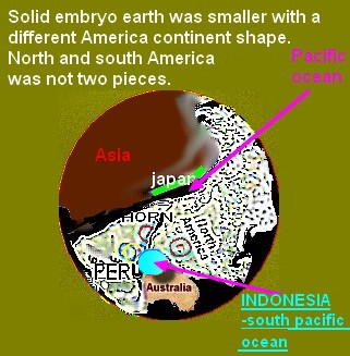
Figure 4. When I forecast Earthquake, floods I always create some imaginary possible maps on my mind. Above map is prior to pacific oceaon created by an explosion from pasific ocean crater. America and Asia was a whole land, then the pasific ocean crater exploded and two lands formed. Then the crater filled with water become the big pacific ocean. That there were only one land before 7 continents is a wellknown hypothesis I found on internet I agree. To this already known one-land Earth hypothesis that my contribution is which I assume the volume of Earth was smaller  at very early historical times, then the volcano (today it corresponds to the pacific-ocean-crater) exploded and increased total volume of Earth in space. Another old crater is Antartika according to my approach
If I have time I may draw this imaginary map better. I created the map using map here.
Meanwhile I am about to draw somehow more complicated force lines over Earthquake-daily-activity-maps, but I need to spend more time to talk more about it. My some unusual force examples are at below(Figure 5a, Figure 5b )
Figure 5a
Figure 5b. The 3 Pink lines direction shows  3 different forces. When forces are not just simple straight lines but unusual as in Figures 5a, 5b, then to predict earthquakes becomes very hard for me.

 Figure 5c. A different example TO SHOW FORCES


Figure 5d. This is a map that I rotated and drawed many lines to connect some activities listed on
11-20-2011. I do not have time to talk about right now, but this is a way I look at maps, activity correlations also.


fİGURE 6. ıF On the current Earth map I was asked to show the very early start of earth formation, which there was hardly solid soil, but mostly HOT gasES METALS. I would consider cross-pointed areas as the first relatively solid appearances. Was this mixture WAS ABOUT TO create mostly  Africa soil ?, I need to investigate further. Then the gas-solid mixture growed and cooled and aparted from todays europe (crosspointed location  ) towards Africa location. moved to create solid lands


**Although floods sometimes kill more people than a 8.0 etc. magnitude earthquake, in my earthquake forecast approach, a flood is a smaller than an Earthquake breaking force. IT MEANS TO ME THAT my quake-feared list may rather have floods, but not big quakes. Predicting earthquakes may also help to predict floods. Sometimes I forecast an earthquake, but only floods occur.
I might need to spend more time to reach details on internet, but such mission extrawork probably would cost me 4 YEARS less life expectancy, anyway that I communicated with this blog to give my approach made me glad that if sometime someone thinks in this way, i am here who does this approach.

P.S.: *I learned maps rather three diomentional with lakes, mountains, rivers, with climates, day-night temperature differences with yearly rain distribution etc. I hardly know cities on the map, I also approximately definetely know how far a location is from ecvator and from pacific ocean. But, I like the coordinate language most to talk on blog to describe ocean quakes better.

P.S: I am in a cOUNTRY located in East Europe right know. Well, after Van 23/10/2011 Earthquake I was a little bit afraid that the city I am in right now(~1700 kilometers away from Van) could have an earthquake to afraid. nobody felt anything(or did not talk about it) but myself ,some thousands of small things I felt prior to 23/10/2011 Earthquake were tremors correlated with Van Earthquake. Their magnitude could never reach even 0.1 mAGNİTUDE, but they existed prior to Van eARTHQUAKE. These tremors are so tiny, it is hard to discriminate them from someone is working on my upper floor to repair house walls. but as of today, 11/2/2011, I am feeling good,
it seems to me that quakes are likely to occur at about south pacific ocean at places no human lives, offshores of continents.  If an earthquakeoccur about mountains, I always check Australia, it isrich in metals to absorb specialwavelengt of sunlight; it is good that this year no big earthquakes occurred in Australia compared to its early times. It is also good that no big Earthquake activity or big floods occurring on Africa continent.

 In future we need tools to record earthquake tremors below 1 SİGNİFİGANTLY.

P..S: Whenever I write the flow-chart of my thoughts, I notice that no language can be fast to catch the speed of thoughts, or images thought in the brain. If we human live 300 YEARS, THEN WE WİLL SPEAK a better language which would be very fast. But, today we live short, we do not have long time to wste time for a fast language for 15 YEARS. Images themselves could be the best language if we would develop a better image compatible language. Well, I do not have time to work on a better faster language. When we speak long words are better for correct understanding, but when writing even short words can be precise, we should make use of written communication. I am never a person who likes learning via listening. I like reading and seeing. Unfortunately, today's primitive education mostly is based on hearing from a teacher who speaks not more than a robot can.
I am a top 10 highest educated scientist of world; when I calculated all my hearing based education, it turned out that only 5% of knowledge was via hearing. Almost all my knowledge was based on either reading or seeing. When I communicate I use hearing and my voice most of the times, but as an educational tool hearing is wrong method.
Well hearing is wonderful when one listens to favorite music on her/his free times. When I study, work I do not like to listen to any music.

Below are two maps (Figure 7, and figure 8) with date 11/4/2011
Figure 7

Figure 8
I will take same location activity after 3, 6 and 9 months laters to show how activity changes by time after the 23/10/2011 Van 7.2 magnitude Earthquake.


fİGURE X. IMAGINARY gAS EMBRYO LAYERS FOR EARTH.
The first imaginary layer is seen from inside of Earth, not from the sky (see the detailed view of south America and Africa here. Think that there is an eye inside of magma, and views towards out.)
aT THİS TİME THE VOLUME OF EARTH WAS SMALLER THAN TODAY.


fıgure XX

FIGURE XXX. Solid-gas mixture of embryo Earth


figure xxxx. Indonesia expanded to south Pacific Ocean during growth of gas Earth embryo.
THE QUESTION IS: wHİCH SEPARATED FİRST?
Africa from ASIA?
or South America from North America?
or occurred simultaneously when Earth was gas-solid embryo.
What was created first? Indian ocean or Mediterranian sea? I believe Indian ocean is older than mediterranian sea.


Pages