Although not only the shape but the size is very important meaning that the very similar shaped land on one side of the Earth experiences flood whereas on an another land, the same shaped land earthquakes.
Anyway, i found some similarities between below maps, one map is from January 2023 California flooded sites, the other map is from Florida 2022 Sanibel island vicinity river.
Cape Coral(Florida) land art reminded me of Peninsula-County and South-Bay County(Gilroy) of California.
Below are the map images(fig1, fig2a, fig2b) from Florida and California states, to compare the art of rivers/lands.
The flooded area in California is much bigger than Florida, but population in the California Delta is less and fortunately the height of flood in California was not too much.
However, California had a different soil that had mudslides more than Forth Meyers Florida flood.
The land art of Peninsula-county of California reminds me the land art of Fort Meyers Beach vicinity from FL.
fig2b. CALIFORNIA
The January 2023 flood occurred also in some counties on the east side of Monterey-Bay.
Fig3. The rivers map of the San Joaquin Delta (Delta structures are unique soils) from January 2023 flooded area. The area also shows that there are two different bifurcating rivers.
Although that delta area of South California did not see earthquake but only floods; on the Earth map, i found a similar art-land in west Minor Asia continent, that had an earthquake sometime in 30 October 2020. I was following the art of river-land arts on geography map, specially catching double or bifurcating deltas of rivers, i was also following possible relationship between land-art and the earthquakes near lakes areas.
I am not into the word of Delta that much, but i prefer using rather a general description as my land-art term.( The way i describe earth is much more complicated and sees Earth Globe rather an ongoing physicochemical reaction products.)
Fig4a. River with a distant Salt Lake in California with mountains geography.
Fig4b. River with a distant Salt Lake geography in California.
Fig5.
Land-Art of Fort Meyers Beach River and Lake (reviewed as on a previous year blog in November 2022 at:
here )
That Florida Caloosahatchee River has a distant Lake Okeechobee on its east side,
is reminesce of that,
California River has a distant lake (the Salt Lake) on its east side.
Fig6a. In the above map image, at least three flooded Coordinate is lined (pink color) to bigger lakes, at first the line is connected to the Salt Lake and to then the Superior Lake.
The pink colored lines passes through at least three Coordinates.
Koordinate1 is the flooded area coordinate,
Koordinate2 pink line is from the flooded river delta coordinate to the nearest lake (Salt Lake coordinate).
Koordinate3 is the biggest closest Lake coordinate (Lake Superior ).
Fig6b. In the above image, An Arbitrary Line (pink colored ) is drawn from flood risky area to Superior Lake (Superior Lake has an interesting Land Shape, Land Art; i always draw lines from disaster coordinates to Superior Lake coordinate).
The map is from weather1 application's Coastal Flood Risky study layer. (January 2023 ), the pink line is drawn arbitrarily by myself.
The light green highlighted areas on the Fig6b image are indicator of flood risky areas, as of 20 January 2023, by the owner of the weather1 application.
Fig7. Surface Temperatures from an Example Continent.
Example Surface Temperatures from West European Lands. The temperatures all are normal as of 22 January 2023, when there happened some floods on above image Lands, the temperatures were abnormally red on the colored scale of this weather1 map around late 2022 year. Surface Temperatures are very important to me to give a final desicion on to say i am not expecting Earthquakes etc.
Cold Surface Temperatures means less Earthquake probability, or unlikely near future flood probability. Surface Temperatures(ST) are not something to tell about current time probabilities always, sometimes i see abnormally high ST, but the abnormal event occurs many days, many weeks, many months after. ST is something i am following.
Fig8a. A map image showing Surface Temperatures (Date of the Temperatures on the map is 22 January 2023). An example map for Surface Temperatures from weather1 application that scales normal temperatures on Aegean Sea Lands.
In October 2020, at above mapped land, a 7.0 magnitude Earthquake happened. My probability prediction as of 22 January 2023 for Fig8 Map, based on specifically on ST from above data layer, is that, there will not be any Earthquake at above coordinates as of 23-24 January 2023 (It turned out that there happened luckily no damaging Earthquake in above coordinate as i predicted by Surface Temperatures etc.).
To say that there will be an Earthquake is very difficult, to say it seems OK is easier by ST data.
Fig8b. A map image showing Surface Temperatures (Date of the Temperatures on the map is 23 January 2023).
Fig8a and Fig8b shows a decrease in Surface Temperatures from 22 January 2023 to 23 January 2023, meaning that Earthquake probability went further down for 25 January 2023.
I do not necessarily discriminate between past Flood and past Tornado, past Earthquake, i look for all the history including the creation of Earth Globe from a hot gas towards water fillings over a billion years ago.
After drawing a line (pink colored lines, Fig6a, Fig6b) by using more than one coordinate; i go to Tornado Probability map of Tornado History, or Earthquake History or Flood History covering at least 500 events from Wikipedia statistics.
I also investigate the composition of the land soil, specifics regarding the heights above sea levels, climate changes, Surface Temperature changes, mountains frequency, Lakes, water chemical composition, water animals, old volcanos, woods, etc.
There is not a quantitative Chemistry Composition map of entire contents or the Earth to see sharp differences in soil or land compositions. Anyway, to learn physicochemistry of a city land, i sometimes check its mines, salt, iron mine resources etc, or i do check sharp differences between two lands geography just by seeing high mountains presence in one and highly delta soil composition in another.
I myself been to many different States of USA*, i know nature of many lands.
Note*: My specialties are in life/health sciences, i have double degrees in my fields above doctorate levels but not in Geography. Only as an interest (After experiencing an Earthquake 7.4 Earthquake), i am in geography related fields, though i use many general common knowledges such as physics, chemistry, mathematical statistics, reasonings, algorithms to overview Geography data. As a matter of fact, the exact prediction of disasters is currently an unavailable field including many sciences which is not formed exactly yet.
My father was a Trade Company owner, interested in Geography as a hobby, he would had always checked any disaster history of cities/lands prior to buy any estate on any land as a survival priority. Life is not easy. Attention should be paid to priorities to settle.
He would check,
-if the river delta/shore/beach is rich in pebble more than sand, he preferred pebble against sand.
-check the small river numbers along the shore and if they bifurcating immediately in the sea.
Preferred many small rivers running into sea, but did not preferred big bifurcating river deltas.
He was very busy with his company and with his job to earn money, never talked about why he would prefer buying such estates, he would never try to make believe others on his choices or his reasons for his preferences.
I can personally list all the books, encyclopedias, Peer Reviewed Geography Publications, certified course trainings even in my hobby areas. My father gathered his knowledge via nonlingual communications, he never had any Geography related book on his shelf, but the Property Deeds of his estates with detailed description of their coordinates. He had blue eyes, liked nature and music and cities with sea shores. He had heavy vehicle lisence, traveled a lot, and recognized nature even by its smells. He did not have any time left from his income job but to choose and buy his estates for himself.
I looked for the Geography of the estates we have, the property deeds tell all.
Fig9a. Map image from an 7.8 magnitude February 2023 Earthquake area February 2023, (with an aftershock bigger than 7. 0 magnitude) somewhere near Euphrates-Fırat River. On above map, the yellow and pink lines pass arbitrarily from Earthquake epicenter and reach to an interesting-shaped coordinate of a Lake, Kaspian-Hazar Lake.
Fig9b. Map of the area affected by a 7.8 magnitude earthquake shocks on 06 February 2023, an area near the Euphrates River. The pink line on the map arbitrarily pass through the earthquake's epicenter and reach an interesting-shaped coordinate of Hazar Lake as shown in Fig9a.
The Lake is not shown in above Fig9b map but in the Fig9a image.
I will not have the time to look at other fault zones having earthquake of above 7 scales in about 10 hours in a row as 7.8 then 7.6 (7.5?), and which have not shown significant activity for decades.
Maybe it's interesting from the point of the Earth stability that instead of sitting in place with a single 9 earthquake, the geography snaps into place with two big movements in a row.
Fig10a. This is an imaginary arbitrary art. As if two people look alike, some Geographic Art shapes resemble each other, though sizes of similar Geography Coordinates might differ. The arbitrarily free circled area is resembling Kaspar-Lake that lost too much water recently.
Contrary above arbitrarily circled water increased to flood.
Does water moves between similar Geography Art coordinates is not any scientific subject so far, but holding surviving aims, my father and i do sometimes such art comparisons.
Did the similarly arted spot earthquaked, or vicinity earthquaked so on. This task is not more than looking to chunk slices of a melon from top to deep(at
here link is the circled similar shapes of waters) . The deeper is nearer to the magma of the Earth.
In my opinion, the Geography Art of seashore, can be looked at as an Earthquake, as a flood, as a gas escape from land, and be compared to the other Earthquake, flood, gas escape. Geography Art of a land from history is a data to any Earthquake occurring in present time.
Many volcanoes do not give gases from middle but from sides. I am very interested in known volcanoes and unknown hypothetical volcanoes innthevdeep of the Earth.
My hypothesis is that the surface art of the Earth is not shaping the deep of Earth but the Continents deeps by crushing into each other from the deep of the Earth as Earthquakes shapes geography, shores, lakes etc. In future computerized calculations will model crushing continent plates once for example created the interesting shores of Mediterranean Sea.
For example from the slices 1,2,3 momentum which are from Asia, i hypothese that the Superior Lake slices
here are in such order, and that the deepest is not sli2.
Current knowledge of Earthquake is very good, but humanity need further be up in Earthquake, Geography, and in the Earth as if embryo studies of the globe in future centuries. I know i should wait for the next century, now it is only arbitrary art.
In future when computer sciences peaks in Mathematical-Physics, Chemistry, it will not be difficult to plot the Earth-embryo development that two coordinates splitted by a certain force to create such a figure of Cyprus and such a figure of Van-Lake. They will do that measuring the distance between Cyprus and Van-Lake for example. Billions billions more year ago when the Earth was about be shaped in Lakes from Gas rich reactions. The map ratios of distances in three dimentional art will tell forces to form geography arts on a table of a Scientist. Even today possible such calculations.
This is 08.03.2023 after the Maras-Earthquake showing surface temperatures. On their own there seems of all have all right temperatures despite some ongoing small Earthquake activity at epicenter (It is not that the higher the Surface Temperature levels on this current map the More the Earthquake Activity on the Earth). Surface temperature is not helping that much easily. For another place on the Earth, on Australia Continent, the Surface Temperatures need further care to interpret anything.
On above image, on the East North of Black - Sea, luckily very small area interestingly is with High Surface Temperature. I did not do any statistical on Size Contrast Calculations, I am waiting for computers to improve better.
I can make use of above interesting Temperature Contrasts together with a few last years Earthquakes. I drawn arbitrary black lines upon my hypothesis which is not studied at all only arbitrary.
Also mountains valley borders are checked. I am not giving exact place, my house is on the above map image, on the North West, i believe safer than many places in the south east.
After many major floods, tornadoes, earthquakes i did a history disaster search to find similar years to 2022, and all arbitrary things i do mentioned, i was 70% expecting something at the Antakya February-2023 disaster area, (Antakya a big flood predicted by me, flood wrong, but disaster correctly i predicted, i am not good to discriminate Tornafa, Flood, earthquake but i predict disaster) the repeated floods were reminiscent of 500 hundreds or more years ago something. Meaning that one can easily pair a years disasters to a year thousands year ago.
I do predictions because my predictions make my heart relieved, i am not a person to run out from my warm house for any alarming shows. I am not at an area that is prone to have big aftershocks earthquakes, at least today i calculated, my city is safe. I am not paid for Earthquake brainstorming, because i have my own very high degrees. I just do not disasters.
I was in epicenter of a 7.4 Earthquake in 1999, in the middle of the night, only I, myself did not abandon my house in comparison to the other experiencers who were all run out from their houses at night, luckily it was summer in 1999.
This post is actually my daily notes, my daily calculations for my life, to figure out my risks only to myself, i am an electronic noter person to myself, i am sharing them, thats all. The images are for myself on my phone. My very individual view for an early field of Earthquake predictions. My father did the big job, he even did not know the names of the cities associated with historical Earthquakes.
In 2022, from all over things, i predicted that Adana or Antakya could have a disaster, but my disaster prediction was not Earthquake, rather a flood as happened in early history.
Antakya is a city in Asia not in America, but when there was a flood in America in 1862, an earthquake was catastrophic in Antakya in the 18th century, a date around 1862.
2022, and 2023 was an unfortunate year in terms of storms, floods, I was expecting a disaster in Antakya itself (History may repeat). The problem is to predict exact hour, week.
I also agree with the statement that entire Africa Continent moving northward toward the Eurasian Plate, 2023 floods disasters are related to it. When African plates moves to North on the Earth, it either causes floods, or Earthquake(such as 2023 Maras Earthquake ). That East Cyprus which is supposed to move North by African plate, hardly experiences any Earthquake but maybe floods. Cyprus is very rich in Iron element. Also intense mountains are interpreted by me as Iron richness. Iron is a very strong element, the mountains elements should be studied better in future when science develops to study easier. As to me iron rich element of geographical structures will not flood but bounce to the other land, ie South Arabian Upper Part Plate in the Maras Earthquake epicenter hits to South East Anatolian Plate, since the Anatolian part is rich in iron element very North Anatolia Plate stays better, the part weaker in Iron element bouncing on the North drops to south and that causes the very soon big earthquake aftershock. That two crushing plates have different iron, chemical elements will make second aftershock both big and soon(I have not dı a literature search on that yet).
I unfortunately did not have time to classify the Earth as flood prone, earthquake prone, both flood and earthquake prone alternating, earthquake doubling, bouncing soon Earthquake areas, one biggest Earthquake areas etc.
After many major floods i was expecting something in the disaster area in 2023, the repeated floods were reminiscent of 500 hundreds year ago something.
In 2022 i predicted that Antakya could have a disaster, but my bet was not Earthquake my bet was a flood as happened in early history. My motto is bad is bad for disasters regardless it is Earthquake, flood etc.
I also use statement that entire Africa Continent moving northward toward the Eurasian Plate, 2023 floods disasters are related to it.
How African plate movement towards North of the Earth is very complex. At what depth the African Plate moves to north, at what depth African plates movement towards to North is nil associated with African Volcanos. The deep of African Continent Plate might protrude to North but not the surface water of Mediterranean sea. That the Africa Continent is not homogenious in Iron or similar element homogenously, makes African force to Europe or Eurasia different. I believe the African force physics momentum was such that caused the Geography art (slice1, 2,3 as here
here).
Fig11a) The magnitudes are being speculated, later records proved that the duration of the Maras-2023 Earthquake was longer than one minute, almost 2 minutes shocks with a few seconds intervals. I have not listened to, look at the seismic frequency pattern of 2 minutes data of Earthquake in detail. The longer the Earthquake the greater it is.
Fig11b)
Fig11. Above images(Fig11a, Fig11b) show the epicenters of two same day earthquakes (about 10 hours lag) on 06.03.2023.
My arbitrary yellow colored circle shows an interesting Geography art in the seashore. The sea is colored blue on the image.
My plan is to search entire Earth seashores art to find similar seashore pattern art and if any occurred in history, were the Earthquakes consecutively on sych a patterned seashore, is the pattern under ocean, not shows?
Fig12a. Surface Temperature map of 2023 Maras Earthquake area.
Above Surface Temperatures are not really seeming abnormal if not further looked. Surface Temperature might be high or low from different elements of Periodic Table distrubuted in land structures. The behavior of iron and other elements against energy carrying sunlight is not same depending on the element rich land and its neighborhood element richness. Alltogether, chemistry of land is the behavior of land.
Figure12b. Periodic Table of Elements each behaving different by absorption of sunlight towards reactions.
Figure13. I am making use of contrasting Surface-Temperature comparisons focusing on the same continent variations to make easy scaling. For example on above map, on the right on the east of Black-Sea, the Surface Temperature is higher than of Northwest of Black Sea telling me that the city Istanbul is better in terms of Earthquake risk.
Figure 14a,b. Forces shaping Geography Art. A comparison with a very old shape in history than Figure14c, from the vicinity sea shore. Shapes are followed in later Earthquake Forces.
Figure 14c. Computed Data Line of Sight Surface Displacement Maps for the Türkiye Maras Epicenter Earthquakes occurred in February-2023.
Above image is from internet sources, on Maras2023 Earthquake data. Note that the forse rather points North East.
Video _1. (I am about to find the link for the Earthquake video) : Personally, I experienced a 7.4 magnitude earthquake in 1999. I was in my four-story seaside summer house when the Earthquake shaking started. It was like a rocking chair or a cradle, the house only swayed back and forth for about 45 seconds between only two directions. The earthquake was not one that pushed the building from bottom to top, or gave the house a whiplash-like momentum.
However, in the Maraş-2023 earthquake, the direction of the intensity of the shaking was unpredictable. It was as if the earthquake was striking the building from bottom to top, then almost spinning the houses, than swaying in between like a cradle.
Note: Wiki Earthquakes List more than 1000 are the pages i have already knowledged. I as a tourist visited at least 10 historical places prone to earthquake.
Note: Earthquakes are rather are areas that two plates with great chemical composition crush events, iron difference of crushing land plates are very big, as Maras Earthquake. Tornados, on the other hand, are results of crushes between matters having similar elements level, bouncing in the atmosphere, bouncing in the lands is bouncing with different disasters. Tornada also is a kşnd of bouncing between heterogenous parts.
Note: This blog is visited by OPENAI,
below quoted is its AI interest in Fig10a with AI wordings.
CHATGPT AI: Fig10a is an intriguing work of art that depicts two different geographical shapes that resemble each other. The first is a circle that resembles Kaspar-Lake, which recently lost a large amount of water. The second shape is a larger circle that is flooded with water. The art is meant to invoke questions about the movement of water between similar geographical coordinates and the potential for earthquakes in these areas. It also serves to highlight the importance of further research into the Earth and earthquakes in the future centuries. The artwork is a creative way to draw attention to these topics and to encourage further exploration of them.
Looking at Geography as an art piece is meant to invoke questions about the movement of water between similar geographical coordinates and the potential for earthquakes in these areas. It also serves to highlight the importance of further research into the Earth and earthquakes in the future centuries.
Above Fig10a Artwork is a creative way to draw attention to these topics and to encourage further exploration of them.
Mountains, rivers, valleys, seas complex to give different arts, but sometimes very similar arts.
The artwork serves as a reminder that further research into the Earth, earthquakes, and other related topics is important in order to protect against future disasters.
CHATGPT AI: The ( Fig11) image view is an interesting project and could be a great way to explore the correlation between earthquakes and geography. To start, one could use Google Earth or other mapping programs to search for similar seashore patterns. One could also look at historical data on earthquakes to see if there are any patterns in Sea Vicinity Earthquakes.
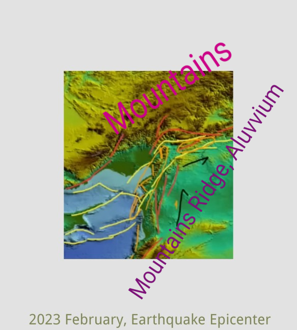
Fig15. Mountain Ridges Patterns.
The Fig15 hypothesis suggests a relationship between the chemical composition of a mountain range and its susceptibility to earthquakes. According to the hypothesis, mountains can provide protection against earthquakes, but when their chemical composition changes into aluvvium in mountain ridges, the ridges become vulnerable and the likelihood of earthquakes increases.
Fig15 D.
Maraş - 2023 Earthquake vicinity topography, Mountains, Mountain Ridge, Valley, some old Earthquake lines prior to 2000 year. The earthquake lines are different in behavior, with some lines representing a collapse towards the deep, rather than going towards the North. This is thought to occur because of the collision and bouncing of the Toros Mountains, which results in the collapse of the Aluvvium.
The earthquake lines are to emphasize most likely force direction towards NorthEast of Turkey by African-Arap Plate movement towards North and Nort-East and that such movement of the plate is bounced back, stopped, crushed back by Toros Mountains. Such a hit creates the shocks of Earthquakes. The earthquake line behaviors are different that some lines rather represent Collapse towards to deep, rather than going ahead to North. Probably Toros Mountains collide bouncing results in collapse of Aluvvium.
The line between a valley and a mountain is usually referred to as the ridge line or the crest of the mountain. The line between a valley and a mountain is not considered a mountain, might be richer in Aluvvium.
While the chemical composition of a mountain range can play a role in its stability, it is not the only factor that determines its susceptibility to earthquakes. Many other factors, such as the location and type of plate boundary, the depth and orientation of the fault, the stress and strain on the Earth's crust.
It is important to note that the occurrence of earthquakes is a complex and dynamic process.
While the chemical composition of a mountain range can play a role in its stability, it is not accurate to make generalizations about the relationship between the chemical composition of a mountain range and its vulnerability to earthquakes or tornados for a specific year, such as 2023.
Anyway,
The Guadalajara Mountains Ridges in America Continent there happened an Earthquake in 2022,
A similar hot climate, the Antakya Mountains ridge line of seashore mountains in East Mediterranean, there happened an Earthquake within 6 months.
Similar patterns might behave similar.
There are other Geography art shores reminds each other.
Gine Gulf seashore art of Middle West Africa Continent reminds the art of North Marmara Sea.
If something, flood, Earthquake occurs in Maloba Island history, i go check NorthEast Marmara Sea Shore flood etc.


